
Del Valle, L., Pons, A., Moragues, A. i Pons, G.X. 2026. Cartografiant el coneixement: SIG i Intel·ligència Artificial com a eines transversals per a la innovació docent en Geografia. Boll. Soc. Hist. Nat. Balears, 69: 147-156. ISSN 0212-260X. e-ISSN 2444-8192. Palma. 
Recepció del manuscrit: 1-08-2026; revisió acceptada: 2-09-2026; publicació online: 2-09-2026.
Aquest projecte d’innovació docent analitza els resultats de la integració transversal dels Sistemes d’Informació Geogràfica (SIG) i la Intel·ligència Artificial (IA) en assignatures del Grau de Geografia tradicionalment no especialitzades en tecnologies geoespacials. La iniciativa, desenvolupada durant el curs 2025–2026 a la Universitat de les Illes Balears. Aquesta metodologia es va aplicar a tres assignatures: Geografia d’Europa, Avaluació d’Impacte Ambiental i Geografia del Paisatge, amb la participació de 68 estudiants. La intervenció es va fonamentar en l’aprenentatge basat en projectes i en l’ús de dades geoespacials oficials per abordar problemàtiques territorials reals. Es varen elaborar guies pràctiques seqüencials per facilitar la creació de bases de dades geoespacials, la producció cartogràfica, la modelització espacial, l’avaluació de riscos ambientals i la interpretació territorial. Les eines d’IA es varen incorporar com a suport per sintetitzar informació, interpretar patrons espacials, resoldre problemes i millorar l’estructura dels informes tècnics, sense substituir el raonament crític de l’alumnat. L’eficàcia de la iniciativa es va valorar mitjançant una metodologia mixta basada en l’avaluació dels productes elaborats, una rúbrica de competències i una enquesta de percepció i satisfacció. Els resultats mostren una valoració molt positiva: el 100% de l’alumnat considerà útils les guies i reconegué que les activitats milloraven la comprensió dels conceptes geogràfics i l’aplicació de la teoria a situacions reals. Així mateix, es constatà el desenvolupament de competències digitals, pensament espacial, autonomia tècnica i capacitat de resolució de problemes. El 80% dels participants proposà ampliar les sessions pràctiques de quatre a sis hores. La iniciativa constitueix un model transferible per integrar els SIG i la IA en altres assignatures i disciplines afins.
Paraules clau: Sistemes d’Informació Geogràfica, intel·ligència artificial, innovació docent, aprenentatge basat en projectes, pensament espacial.
This teaching innovation project analyzes the results of cross-curricular integration of Geographic Information Systems (GIS) and Artificial Intelligence (AI) into undergraduate Geography courses that are not traditionally focused on geospatial technologies. The initiative was implemented during the 2025–2026 academic year at the University of the Balearic Islands. This methodology was applied to three subjects: Geography of Europe, Environmental Impact Assessment, and Landscape Geography, involving 68 students. The intervention was based on project-based learning and the use of official geospatial datasets to address real-world territorial problems. Step-by-step practical guides were developed to support the creation of geospatial databases, cartographic production, spatial modelling, environmental risk assessment, and territorial interpretation. AI tools were incorporated as complementary resources for synthesizing information, interpreting spatial patterns, supporting problem-solving, and improving the structure of technical reports, without replacing students’ critical and analytical reasoning. The effectiveness of the initiative was assessed through a mixed-method approach combining the evaluation of student outputs, a competency-based rubric, and a perception and satisfaction survey. The results reveal a highly positive assessment: all participants considered the practical guides useful and reported that the activities improved their understanding of geographical concepts and their ability to apply theoretical knowledge to real-world situations. The completed geodatabases, thematic maps, spatial models, and technical reports also demonstrated the development of digital competencies, spatial thinking, technical autonomy, and applied problem-solving skills. Furthermore, 80% of the students recommended extending the practical sessions from four to six hours to allow more time for data processing, spatial analysis, and discussion. Overall, the initiative provides a transferable framework for integrating GIS and AI across Geography courses and related disciplines, strengthening the connection between academic learning, professional practice, and complex territorial and environmental challenges.
Keywords: Geographic Information Systems, artificial intelligence, teaching innovation, project-based learning, spatial thinking.
Laura DEL VALLE, Antoni PONS, Alexandre MORAGUES, Guillem X. PONS, Departament de Geografia. Universitat de les Illes Balears, Ctra. de Valldemossa km 7,5, 07122 Palma.
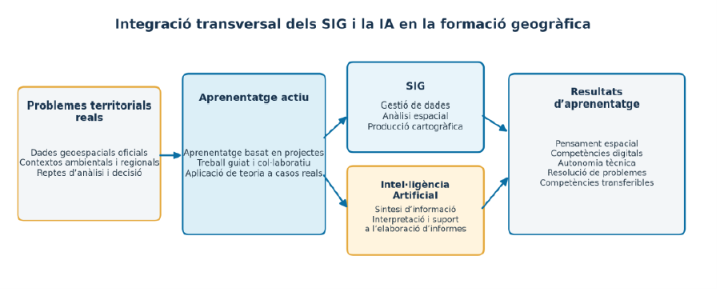
Conceptual framework of the educational innovation project PID 252713. The model illustrates the integration of Geographic Information Systems (GIS) and Artificial Intelligence (AI) into active learning environments, enabling students to address real-world territorial problems through spatial analysis, cartographic production, and geospatial data-driven decision-making. Source: Authors’ own elaboration.


I appreciate your kindness. I've just sent you an email with the contact address of Joaquín. Kind regards. Miguel McMinn